Thunderstorms
Powerful Convective Weather Systems
Cloud Type
Cumulonimbus (Cb) - The only cloud that extends through all three atmospheric levels, from 300m to 12,000m+ in altitude
Key Feature
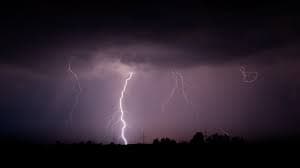
Lightning & Thunder - Electrical discharge from ice particle collisions within the cloud, releasing millions of volts
Severity
Extreme Hazard - Most dangerous common weather phenomenon, produces multiple severe weather events
What is a Thunderstorm?
A thunderstorm is a localized, short-lived atmospheric disturbance accompanied by lightning, thunder, moderate to heavy rain or hail, and sometimes damaging winds and tornadoes. Thunderstorms result from vigorous convection driven by heat and moisture from the surface. They represent one of nature's most violent and dangerous weather systems, affecting a relatively small area but producing intense phenomena within that region.
Formation Process
Thunderstorms develop through three distinct stages, each with characteristic features and behaviors.
1. Cumulus Stage
Warm, moist air rises from the surface in updrafts reaching 10-20 mph. Cumulus clouds form as water vapor condenses. The cloud base remains sharp and clean, with strong updrafts supporting continued growth.
- • Latent heat release from condensation strengthens updrafts
- • Cloud top temperature drops with altitude
- • Droplets remain unfrozen despite rising
2. Mature Stage
Peak intensity occurs with both updrafts and downdrafts present. Precipitation becomes heavy with hail at mid-levels. Intense updrafts (30-50+ mph) can reach tropopause, creating anvil top.
- • Intense lightning and thunder
- • Heavy rain (greater than 1 inch per hour)
- • Large hail and damaging winds
- • Possible tornado development
3. Dissipating
Downdrafts dominate as rain-cooled air sinks and spreads. Updrafts weaken, precipitation decreases. Lightning becomes less frequent but may persist. Storm weakens and dissipates into stratiform clouds.
- • Strong outflow winds from downdrafts
- • Gust fronts racing ahead of rain
- • Circulation weakens progressively
Atmospheric Ingredients Required
Thunderstorms need three essential ingredients to develop - without all three, storms cannot form or maintain intensity.
Moisture
Abundant water vapor near the surface provides the fuel for thunderstorm development. Dewpoints above 55°F (13°C) significantly increase storm potential.
- • Below 50°F: Limited storm potential
- • 50-55°F: Marginal conditions
- • 55-60°F: Moderate conditions
- • Above 60°F: Very favorable
Instability
Warm, moist air at the surface overlying cooler air aloft creates unstable conditions. This promotes vertical motion and strong updrafts. Measured by CAPE (Convective Available Potential Energy).
- • Below 500: Minimal thunderstorm threat
- • 500-1500: Weak potential
- • 1500-3000: Moderate potential
- • Above 3000: Strong potential
Lifting Mechanism
Air must be forced upward to initiate convection. Mechanisms include cold fronts, mountains, sea breeze boundaries, and areas of wind convergence.
- • Cold front passages
- • Orographic lift (mountains)
- • Dry line boundaries
- • Outflow boundaries
- • Daytime solar heating
Primary Hazards & Phenomena
Lightning
Massive electrical discharge resulting from ice particle collisions generating charge separation within clouds. Lightning heats air to 50,000°F (27,760°C) in milliseconds.
- • Peak current: 30,000 amps average
- • Duration: 0.2 seconds entire process
- • Temperature: Exceeds sun's surface
- • Speed: 1/3 speed of light (return stroke)
- • Range: Can strike 10+ miles from storm
- • Deaths: ~20 annually in U.S.
Heavy Rain & Flash Flooding
Intense rainfall rates exceeding 1-4 inches per hour overwhelm drainage systems and create dangerous, life-threatening flash flooding in minutes.
- • Typical storm: 1-3 inches
- • Intense cells: 5-10 inches possible
- • Dangerous flash flood threshold: 2+ inches/hour
- • Vehicle sweep threshold: 18 inches flowing water
- • Deaths: More than any other thunderstorm hazard
- • Time to onset: Minutes, not hours
Severe Hail
Large ice balls form in the frozen precipitation region of strong updrafts, cycling between zones of different temperature through a storm's core. Golf ball-sized and larger hail causes severe damage.
- • Formation: Repeatedly cycling through updrafts
- • Severe size: Golf ball (1.75 in) or larger
- • Falling velocity: 100+ mph for large stones
- • Storm environment: Very strong (CAPE above 3000)
- • Regional hotspot: Hail Alley (Colorado/Wyoming)
- • Damage: Crops, roofs, vehicles, windows
- • Cost: Billions annually in damage
Damaging Winds & Derechos
Straight-line winds from downdrafts and outflows can exceed 100 mph, snapping trees, damaging structures, and creating windblown debris. Multiple storms moving together form derechos.
- • Downdraft winds: 50-100+ mph
- • Derecho definition: 75+ mph winds over 240 miles
- • Mechanism: Cold pool outflows and wind shear
- • Damage path: Can exceed 500 miles
- • Visibility: Often in advance of rain
- • Trees: Snapped, uprooted, debarked
- • Structures: Roofs removed, walls collapsed
Tornado Development
Supercell thunderstorms with rotating mesocyclones have the highest tornado potential. Tornadoes form from rotation aloft extending to the surface, creating the most violent rotating updraft.
- • Storm type: Supercells with mesocyclones (most common)
- • Rotation: Develops at mid-levels first, extends to surface
- • Wall cloud: Lowering often precedes tornado
- • Detection: Radar hook echo (velocity couplets)
- • Wind speeds: EF0-EF5 scale (65+ mph to 200+ mph)
- • Duration: Seconds to minutes typically
- • Path width: 100+ yards to several miles possible
Types of Thunderstorms
Single-Cell (Air-Mass) Storms
Characteristics: Single updraft/downdraft pair, weakly organized, brief lifecycle (15-30 minutes).
Formation: Daytime heating in weak wind shear environments, scattered development.
Severity: Generally mild, occasional lightning and brief rain. Hail and tornadoes rare.
Frequency: Most common thunderstorm type on summer afternoons.
Multi-Cell Clusters
Characteristics: Multiple cells at different stages, organized line or cluster, moderate longevity (1-3 hours).
Formation: Moderate wind shear, outflow boundary interaction, development in sequences.
Severity: Large hail, heavy rain, severe wind gusts, occasional tornadoes.
Hazard: Sustained severe weather threat through propagation of new cells.
Supercells
Characteristics: Single persistent rotating updraft, organized structure, long lifespan (1-4+ hours).
Formation: Very strong wind shear and instability, high-end severe environments.
Severity: Most violent storms - giant hail, extreme winds, frequent violent tornadoes.
Rarity: Less than 5% of all thunderstorms but responsible for majority of violent severe weather.
Derechos (Bow Echoes)
Characteristics: Squall line with prominent bow-shaped leading edge, high organization, can sustain 500+ miles.
Formation: Strong wind shear and instability, organized ahead of cold front or dry line.
Severity: Extreme straight-line winds, widespread damage, occasional embedded tornadoes.
Impact: Can produce significant impacts comparable to hurricanes across multiple states.
Detection & Monitoring
Radar Signatures
- • 40-50 dBZ: Strong precipitation
- • 50-60 dBZ: Heavy precipitation
- • 60+ dBZ: Hail likely, extreme values indicate large hail
- • Bounded weak echo: Hail core marker
- • Velocity couplets: Strong rotation
- • Hook echo: Mesocyclone rotation
- • Shear zones: Wind change boundaries
- • Debris signature: Tornadic circulation
- • Overshooting top: Very strong updraft
- • Notch on inflow: Supercell structure
- • Striations: Wind shear organization
- • Mammatus clouds: Instability above
Visual Indicators
- • Dark, lowered cloud base
- • Rotating wall cloud (mesocyclone)
- • Striations (wind shear pattern)
- • Beaver tail appendage (inflow)
- • Mammatus clouds (turbulence)
- • Greenish sky (hail possible)
- • Extreme darkness at mid-day
- • Rapid wind shifts/increase
- • Heavy rainfall reducing visibility
- • Funnel cloud development
Safety Preparation & Response
Before Storms Arrive
- ✓ Monitor weather forecasts and alerts regularly
- ✓ Identify nearest shelter location (interior room, basement)
- ✓ Know the difference between watches and warnings
- ✓ Have multiple ways to receive warnings (radio, phone, apps)
- ✓ Charge batteries and keep flashlights accessible
- ✓ Secure outdoor objects that could become projectiles
- ✓ Trim trees and maintain roof/structure integrity
- ✓ Have emergency contact information available
During Severe Thunderstorm Watch/Warning
- ✓ Move away from windows and exterior walls
- ✓ Avoid using phone/electrical appliances
- ✓ Don't shower or bathe during storms
- ✓ Keep children and pets indoors
- ✓ Avoid large open rooms with wide roofs
- ✓ Stay informed with weather updates
- ✓ Be ready to take shelter immediately if needed
- ✓ Don't go outside to watch the storm
During Tornado Watch/Warning
- ✓ SEEK SHELTER IMMEDIATELY: Go to basement or interior room on lowest floor, away from windows and exterior walls
- ✓ Stay away from doors and windows - they are points of weakness
- ✓ Cover yourself with mattress, pillows, or helmets for protection from flying debris
- ✓ If in a mobile home: EVACUATE to sturdy shelter (do not stay)
- ✓ If in a large building: Go to small interior room or hallway
- ✓ If caught outside with no shelter: Lie flat in a ditch or low-lying area, cover your head
- ✓ If in a car: Abandon vehicle and seek shelter or lie flat outside
- ✓ Do not try to outrun a tornado in a vehicle
- ✓ Wait 30 minutes after last thunder before leaving shelter
Thunderstorms in a Changing Climate
Climate change is altering thunderstorm behavior in several important ways. Warmer temperatures increase atmospheric instability and moisture availability, potentially leading to more intense individual storms despite potentially fewer storm days overall.
- • Increased CAPE values in many regions
- • Heavier precipitation rates when storms do occur
- • Longer-lasting supercells with extended severe weather
- • Potential shift in seasonal thunderstorm peaks
- • More frequent extreme rainfall events and flash flooding
Understanding these changes helps communities and individuals better prepare for increasingly intense atmospheric phenomena in the future.
Key Facts Summary
- • Global frequency: ~2,000 thunderstorms at any moment
- • Annual US storms: ~100,000 thunderstorms
- • Lightning strikes: ~25 million annually in US
- • Hail cost: ~$10 billion annually (crops + property)
- • Deaths per year: ~80-100 in US (declining due to warnings)
- • Peak season: May-July in most of US
- • Peak time: Afternoon to early evening (instability max)
- • Most hail: Eastern Colorado and Wyoming
- • Most tornadoes: Tornado Alley (OK, KS, NE, TX)
- • Largest hail ever: 8 inches diameter (South Dakota 2010)