Mesocyclones ⚡
Understanding rotating columns of air within thunderstorms
What Are Mesocyclones?
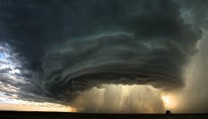
Mesocyclones are rotating columns of air that develop within supercell thunderstorms. These powerful vortices form when wind shear causes horizontal rotation in the atmosphere, which is then tilted vertically by the strong updraft of a severe thunderstorm. They can range from several hundred feet to several miles in diameter and often precede tornado formation.
Key Characteristics
- • Size: 1 to 10+ miles in diameter
- • Rotation: Counterclockwise (NH)
- • Duration: 10 minutes to hours
- • Location: Mid-level of thunderstorm
Threat Level
Mesocyclones are strong indicators of severe weather potential. They frequently produce large hail, damaging winds, and are the most reliable indicator of tornado development. Detection via radar is crucial for storm spotting and warning issuance.
How Mesocyclones Form
The formation of a mesocyclone involves several atmospheric processes working together:
Wind Shear
Changing wind direction and speed with height creates horizontal spinning motion in the atmosphere.
Tilting Process
The strong updraft in a supercell tilts this horizontal rotation into a vertical axis.
Stretching
As air rises into the mesocyclone, it stretches vertically, intensifying the rotation like a spinning skater pulling in their arms.
Tornado Development
The intense rotation can tighten and extend downward, sometimes producing tornadoes as it reaches the ground.
Detection & Warning
Radar Detection
Meteorologists detect mesocyclones using Doppler radar, which shows rotation patterns in wind velocity. The hook echo signature on radar is a classic indicator of mesocyclone presence and potential tornado development.
Visual Signs
Storm spotters watch for rotating clouds, wall clouds with circular motion, and organized thunderstorm structure. A lowering or tightening wall cloud often indicates mesocyclone intensification.
Associated Hazards
Tornadoes
Mesocyclones produce the majority of violent tornadoes, particularly supercell tornadoes.
Hail
Severe hail, sometimes exceeding baseball size, is common in mesocyclone-bearing supercells.
Damaging Winds
Extreme wind speeds can exceed 100 mph, causing significant structural damage.
Safety During Mesocyclone Activity
• Monitor weather alerts: Pay attention to Severe Thunderstorm and Tornado Warnings
• Seek shelter: Move to an interior room on the lowest floor, away from windows
• Avoid driving: Do not attempt to outrun or intercept mesocyclones
• Have a plan: Know your safe room location before severe weather arrives
• Stay informed: Use weather radios and emergency alerts for real-time updates